Custom Query (432 matches)
Results (91 - 93 of 432)
| Ticket | Resolution | Summary | Owner | Reporter |
|---|---|---|---|---|
| #130 | fixed | Support: 22/Apr/2008, Ricardo Díaz-Delgado, EUFAR07/01 | mggr | mggr |
| Description |
Ricardo contacted us yesterday with: Recently you offered your help with any general Eagle/Hawk/CASI/ATM processing issues and we would like to consult about our Eagle/Hawk data processed with azgcorr. As you maybe are aware, Doñana (SW Spain) was overflown March last year and we have been using azgcorr to produce Level 3 geocorrected data, and able to apply atmospheric corrections with the great help of Andrew Wilson from CEH. However, to manage the huge files of the geocorrected Level 3 data at full spatial and radiometric resolution is still a pain because of file size, specially in cases in which we have lots of ground-thruth positions in different flight-lines (our main EUFARNet aim and goal is to map 2 allien plant species). That is why we are also trying to obtain IGM files for ENVI (X and Y coordinate files that help in overlying ground-truth areas, more info at http://www.ittvis.com/services/techtip.asp?ttid=3816), and this is why we are testing the possibility to do it with PARGE since AZGCORR has not this option (although the calculations must be embedded somewhere in the code, during the geocorrection process, as Andrew Wilson indicated). This might simplify the process of overlaying ground-truth on flight-lines before applying any geocorrection to the final product (mostly classification maps). Would it be possible to incorporate such an option on AZGCORR processing? As this is not the only project in which we are working, and we are not experienced hyperspectral data users, it is taking us longer than we would have liked to analyse the data. The IGM files appear to be ENVI's method for specifying per pixel coordinates. This is the same issue as #109. Replying to Ricardo with the info we have on this, and the current tentative plan for this to be implemented pending availability of development time. Raising the importance of that issue too. |
|||
| #131 | fixed | Boresight, flight day 116/2008, Monks Wood | knpa | mggr |
| Description |
Data location: ~arsf/arsf_data/in_progress/2008/flight_data/arsf_internal_projects/boresight-2008_116/ Data arrived from ARSF via rsync transfer begun 28/April, completed 29th (~19hrs/15GB). Scientific details: N/A PI: ARSF This boresight also includes a long line along a railway track, with wiggles, per action item in the recent meeting. Sensors:
QuicklookTBD. |
|||
| #133 | fixed | FODIS processing appears incorrect | mggr | mggr |
| Description |
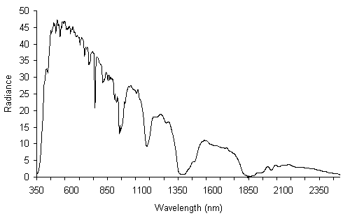
With the recent acquisitions of the first FODIS data, we attempted to process some using azspec and appear to have a problem. By comparison with the solar spectrum (http://fsf.nerc.ac.uk/img/g37_grph.gif) and a Caligeo processing of the same line, there is a clear discrepancy. Image below shows a worst case selection of the azspec FODIS output.
relevant part of processing log: azspec -- ver: 1.1.7 Apr 3 2008 (C) Azimuth Systems UK 2005, 2007
Raw file header: eagle/VNIRsecloudtest-1.hdr
Raw file : eagle/VNIRsecloudtest-1.raw
Dark frames at end of image file, 152 frames starting at: 3932
Image lines corrected from: 4083 to 3931
Using Tr multiplier from spectral binning[2]: 1.00 fsmscale is now: 0.000100 Tr: 0.002000 integ: 20.0
Optics from basic details and binning port fov: 16.129 full fov: 34.688 corr oa: 512.00 scpixels: 953
image file frame count start: 60092 end: 64047 total lines: 3955 file lines: 3931
Dark frames at end of raw file: 152 darks to be used: 50
Dark frames used: 49.0 scale: 0.02041
Radcal file header: calibration/eagle/SN100022_130207_XB.hdr
Radcal file : calibration/eagle/SN100022_130207_XB.cal
Config file : calibration/eagle/SN100022_130207_XB.cfg
Using HDF file: lev1/eJJJ011b_gpt0.0.hdf
HDFStart fov: 34.7 fovp: 16.1 scpixels: 953
New BIL bands: 252 pix: 953 lines: 3955
HDF image data: CAimage bands: 252 pixels: 953 lines: 3955
FODIS (ILS) bands: 252 pixels: 1 lines: 3955
2 frame(s) missing from: 60094 to 60097 line: 2 cline: 3
2 frame(s) missing from: 60098 to 60101 line: 6 cline: 5
2 frame(s) missing from: 60102 to 60105 line: 10 cline: 7
1 frame(s) missing from: 60112 to 60114 line: 20 cline: 15
1 frame(s) missing from: 60115 to 60117 line: 23 cline: 17
3 frame(s) missing from: 60118 to 60122 line: 26 cline: 19
2 frame(s) missing from: 60126 to 60129 line: 34 cline: 24
1 frame(s) missing from: 60130 to 60132 line: 38 cline: 26
2 frame(s) missing from: 60133 to 60136 line: 41 cline: 28
2 frame(s) missing from: 60138 to 60141 line: 46 cline: 31
2 frame(s) missing from: 60142 to 60145 line: 50 cline: 33
2 frame(s) missing from: 60146 to 60149 line: 54 cline: 35
1 frame(s) missing from: 60157 to 60159 line: 65 cline: 44
2 frame(s) missing from: 60964 to 60967 line: 872 cline: 850
**FrameProcess - HDF write error for ILS line: 3955
SpecNavProc gotsync: 0 synclater: 1
Nav syncstart from image file header of: 49107.62500 gps secs of day
sync entries set for later use
start frame: 0 end: 3954
start frame time: 49107.624900 frame time increment: 0.033333 secs
writing new NAV vgroup
Processing summary...
data from : AISA HS Instrument, SW ver 2.800
sensor ID : 100022
lens FOV : 34.69 degs
raw file : eagle/VNIRsecloudtest-1.raw
BIL lines : 3931 available
acq date : 31/01/2008 day: 31
rec times : start: 13:38:27.62 end: 13:40:45.19
binning : 2 spectral 1 spatial
integration : 20.00 msecs
frame rate : 30.00 fps
radiance sc : 1000.000
HDF file : lev1/eJJJ011b_gpt0.0.hdf
Image data : pix: 72 to 1024 saved to HDF-SDS item: CAimage
FODIS (ILS) : pix: 28 to 32 saved to HDF-SDS item: CAils
pixels : 1024
bands : 252 re-ordered blue to red
image lines : 3955 frameIDs at line (0): 60092 and line (3954): 64047
Processing applied...
frame shift smear correction, line shift scale: 0.00010
dark frame subtraction, lines averaged: 50 dark frames from raw file
radiometric calibration using file: calibration/eagle/SN100022_130207_XB.cal
** total pixels overflowed after calibration: 556
FODIS averaged
** no FODIS ratio applied
Processing times : calibration: 64.2 total: 237.6 secs
halting after azspec (no need to do the rest)
Sent a copy of the Caligeo and azspec processed files, the raw data and the script to Bill, with a brief explanatory note. |
|||