Opened 16 years ago
Last modified 14 years ago
#356 closed flight processing
EUFAR10/03, flight day 196/2010,Lisbon — at Version 28
| Reported by: | ella | Owned by: | knpa |
|---|---|---|---|
| Priority: | alpha 4 high | Milestone: | 2010 data processing completion |
| Component: | Archiving | Keywords: | |
| Cc: | Other processors: |
Description (last modified by emca)
Data location: ~arsf/arsf_data/2010/flight_data/western_europe/EUFAR10_03-2010_196_Lisbon
Data arrived from ARSF via network transfer on 2nd/08/2010.
Scientific objectives:
Objective 1.- Development of a reliable tool to estimate coastal water quality indicators by using remote sensing
techniques, both airborne and satellite.
1.1. | Development of a set of semi-empirical algorithms based on hyper-spectral airborne and in-situ data for
estimating the concentrations of the water constituents;
1.2. | Migration of the developed algorithms into the satellite workflow.
Priority: a4h
PI: Jose da Silva
Sensors:
- Eagle (Requested by PI)
- Hawk (Requested by PI)
- Leica LIDAR (03/12/2010)
- RCD Camera (03/12/2010)
Change History (29)
comment:1 Changed 16 years ago by ella
- Description modified (diff)
- Priority changed from alpha 4 medium to alpha 4 high
comment:2 Changed 15 years ago by ella
comment:3 Changed 15 years ago by jb362
IPAS navigation processing done.
comment:4 Changed 15 years ago by ella
Waiting for logsheet.
Applanix processing was problematic because the flight was 100km away from the nearest base station.
POSproc failed to create an Sbet file.
comment:5 Changed 15 years ago by jb362
Starting camera processing.
comment:6 Changed 15 years ago by emca
Starting LiDAR processing
comment:7 Changed 15 years ago by emca
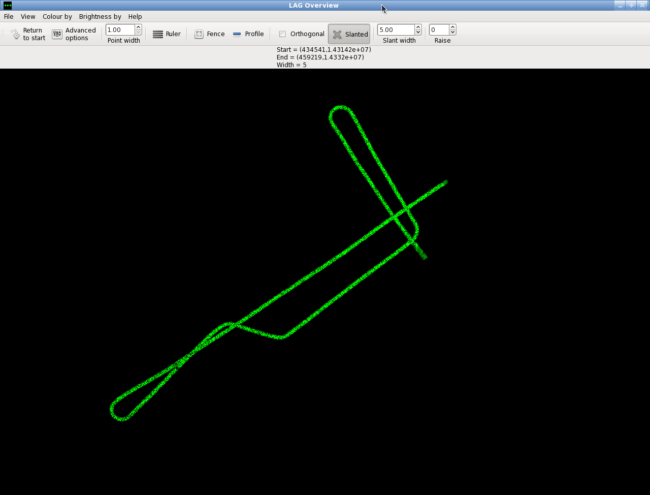
There are six LiDAR lines for this project.
Lines 1 and 2 are very short, contain very little data (approx 30% first returns) and are very noisy. From the leica flightline log it it looks like there was also an issue with the range correction during the capture of these lines.
Lines 3 and 4 contain no useful data.
Line 5 is partially over water and contains a 90 degree turn.
Line 6 consists of four distinct lines, including the turns in between (see attached screenshot). This may need to be separated into 4 lines.
There is little overlap between lines (just the cross of Line 6 with itself) which will make correcting for roll difficult.
Going to wait until next week when ARSF Ops return and we can get the logsheet before proceeding any further with this project.
comment:8 Changed 15 years ago by jb362
Started camera processing for this project but in the kml file it's very hard to see which images will be needed and which won't. This is because it the camera wasn't turned off between flight lines. This processing will therefore be held until we have the logsheet for this project. If I have left before we do get the logsheet iopa will be picking up the camera processing.
comment:9 Changed 15 years ago by jb362
Also, all the .tif files for the camera processing have already been created.
comment:10 Changed 15 years ago by emca
Call from Phil to say there are still looking for the logs sheets for this project as well as for Lisbon flight day 197
Both projects were flown on an ad hoc basis. They were unable to turn the LiDAR off during the flight as they were flying over water but the hyperspectral was switched off between lines to conserve disk space. As a result there will not be a match between the eagle/hawk and the LiDAR lines.
comment:11 Changed 15 years ago by emca
Logsheet has arrived and been saved in ~arsf/arsf_data/2010/flight_data/archive-overflow/EUFAR10_03-2010_196_Lisbon/admin
comment:12 Changed 15 years ago by jb362
Iopa will be taking over this camera project.
comment:13 Changed 15 years ago by ella
Starting camera delivery check.
comment:14 Changed 15 years ago by ella
Camera check complete.
Two photos have been removed and the read_me and kml file have been updated.
Ready to deliver.
comment:15 Changed 15 years ago by iopa
- Description modified (diff)
RCD camera was dispatched today, 16th September 2010.
comment:16 Changed 15 years ago by knpa
- Owner set to knpa
- Status changed from new to assigned
Taking over hyper-spectral processing for this project.
comment:17 Changed 15 years ago by knpa
Issue with applanix - raw data in two parts with a gap in the middle. This gap covers one of the lines (Gen3).
Also, cannot find eagle data for first two lines (Gen 1/2) and (Gen 3).
comment:18 Changed 15 years ago by knpa
- Description modified (diff)
Move to repository, can be rsynced.
comment:19 Changed 15 years ago by knpa
Phone call from Phil to Ben:
The data collection for this project starts at 11:39 and earlier lines are tests.
That excludes Gen1/2 and Gen3, meaning that this project now has 5 lines containing eagle and hawk data that will be processed.
comment:20 Changed 15 years ago by knpa
SCTs impossible to correct on this project as almost all lines are over water.
H6 had no sync but managed to correct gross sync issues by matching water patterns with eagle.
SCTs
| Eagle | Hawk | |
| Line 1 | 0 | 0 |
| Line 2 | 0 | 0 |
| Line 3 | 0 | 0 |
| Line 4 | 0 | 0 |
| Line 5 | 0 | 1.5 (sync) |
comment:21 Changed 15 years ago by knpa
Correction: above Hawk 5 value should be 0.15 NOT 1.5.
comment:22 Changed 15 years ago by knpa
First 12 bands of Hawk lev1s are blank. The raws are fine. Appears to be an issue with the bandset labels in the header files, they start at 900nm which is lower than it should be. Possibly incorrect bandset selected or none specified. Will leave this until end of the year and new Hawk calibration.
comment:23 Changed 15 years ago by benj
- Description modified (diff)
Corrected PI (recorded wrong on data unpacking)
comment:24 Changed 15 years ago by knpa
Eagle processing has been completed.
PI has said they want to wait until until both hyperspectral datasets can be delivered together (i.e. until hawk is ready in December at earliest).
(e-mail 25/10/10).
comment:25 Changed 15 years ago by emca
LiDAR data ready for delivery check at
~airborne/workspace/EUFAR10_03-2010_196_Lisbon/delivery/20101109/EUFAR10_0
LiDAR data for lines for UL005 & UL0066 only. UL006 was very long so it has been split into three to correspond roughly to the three Eagle/Hawk lines.
Note: It was not possible to correct for roll on this project. Did not create a DEM from the LiDAR data as it is mostly over water.
comment:26 Changed 15 years ago by benj
- Description modified (diff)
comment:27 Changed 15 years ago by iopa
LiDAR has been checked,
the data and directories are fine considering there is no DEM.
there is only a typo in the readme in the data quality section where it should be 'manageable'
otherwise LiDAR is ready.
comment:28 Changed 15 years ago by emca
- Description modified (diff)
LiDAR and Photography dispatched 03/12/2010
(note: photography is a re-delivery as data sent on 16/09/10 was sent to the wrong PI)
Starting navigation processing.