| Version 1 (modified by mark1, 14 years ago) (diff) |
|---|
Airborne Processing Library - Quick Start
This is a short guide aimed at getting users geocorrecting their data straight away. For more in depth information please refer to the APL mapping user guide pdf.
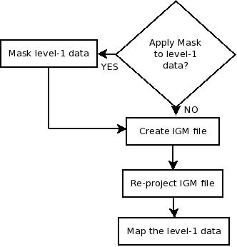
Creating an IGM file
An IGM file is a file that contains per-pixel latitude, longitude and height information, and relates directly to the level 1 file. Using the data contained in an ARSF delivery this can be done using the following command for an Eagle image, where the level 1 data file is named flightline1.bil and the output IGM file will be called flightline1.igm. The DEM used is the ASTER DEM as provided with the hyperspectral delivery.
aplcorr -lev1file flightlines/level1b/flightline1.bil -igmfile my_output/flightline1.igm -vvfile sensor_FOV_vectors/eagle_fov_fullccd_vectors.bil -navfile flightlines/navigation/flightline1_nav_post_processed.bil -dem dem/GB11_00-ASTER.dem
We now have per-pixel longitude and latitude values for the level 1 data of file flightline1.bil. But say we want to map the data to a different coordinate system. For this we need to re-project the IGM data.
Reprojection from Geographic Latitude / Longitude
Reprojection is done in APL using the apltran software. This uses the open source PROJ libraries for performing the reprojection. There are 2 projections that have quick keywords set up in apltran; Ordnance Survey National Grid (OSTN02) and WGS84 Universal Transverse Mercator (UTM). To reproject flightline1.igm into UTM Zone 31 we could do the following:
apltran -inproj latlong WGS84 -igm my_output/flightline1.igm -output my_output/flightline1_utm31.igm -outproj utm_wgs84N 31
Attachments (1)
-
apl_flow.jpeg
(14.6 KB) -
added by mark1 14 years ago.
apl flow chart
Download all attachments as: .zip