| Version 6 (modified by mark1, 14 years ago) (diff) |
|---|

Sensors Operated by ARSF
The page gives a list of past and present sensors operated by ARSF. Click on the name below to get more information about a specific sensor.
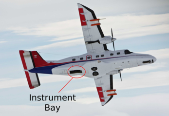
The sensors are mounted on the cabin floor over an opening that can be opened/closed during flight. The image below shows the aircraft in flight with the hatch open.
Current Sensors
ARSF currently operate both Specim AISA Eagle and Hawk sensors, a Leica ALS50-II LiDAR and a Leica RCD105 39 mega-pixel camera. There is also a downwelling light capture device operated called the FODIS. For comparison on ATM, CASI, Eagle and Hawk sensor swath widths see this figure.
Navigation System

The navigation data that is used in the georeferencing of the various sensor data is collected from either an Applanix system (for pre-2011 data collections) or an IPAS system (for 2011 data onwards). See the ARSF operations navigation systems page for more information.
Additional Instruments Available
- Tabi
- Aimms + Grimm
Historical Instruments
Attachments (1)
- dcalm_bay.png (361.3 KB) - added by emca 14 years ago.
Download all attachments as: .zip