Custom Query (432 matches)
Results (334 - 336 of 432)
| Ticket | Resolution | Summary | Owner | Reporter |
|---|---|---|---|---|
| #109 | fixed | Output of ground coordinates in azgcorr | mggr | mggr |
| Description |
It would be useful if azgcorr could output some extra information on the mapping of points. Peter Land was interested in level 1 ground coordinates per pixel. Chris Hecker (#108) has requested per-pixel geocoordinates or per pixel view vector info for feeding into ATCOR, also presumably at level 1. He said ATCOR needed, as an input parameters for the atmospheric correction model, the viewing geometry and distance between plane and each pixel. This can be supplied either as:
Peter contacted Bill about it, who replied (1/May/2007) with: The option to 3D output pixel coordinates, solar and sensor view vector details and time are on the cards for Andrew's group to use with Modtran, so in the not too distant future will be available. |
|||
| #108 | fixed | Support: 28/Mar/2008, Chris Hecker, WM06/06 | mggr | mggr |
| Description |
New contact from Chris with some atmospheric correction questions (note #42 for previous support) Hi Mike; after a few months of radio silence, I have a question for you again! ;-) I am wanting to do atmospheric correction on the 2006 Mojacar Eagle and Hawk data with ATCOR4 ( http://www.rese.ch/atcor/atcor4/index.html). For that I need to also input - a sun elevation and sun azimuth file (which I should be able to do with some freeware software) - a scan angle file with the viewing vector for each pixel (azimuth angle, zenith, angle, height of plane). Gary mentioned that you may be the person best suited to judge which workaround or tool from the user community is available for that. He mentioned that Matt Disney from London had retro-engineered the info in the past for BRDF studies. Do you know anything about that and are these tools(?) available? The other question is about the metadata info in the hdf file. I presume that folder "Navigation" contains info from the plane's IMU (NVhead, NVpitch NVroll), and GPS (NVlat NVlng NVhgt) and that the folder "Coordinates" contains info from a ?second IMU (COhead, COpitch COroll) and a ?second GPS (COlat, CO lng, COhgt) which are positioned near the instruments. Is that correct? What do the values in COqual represent? Do you have a document that explains the different tags in the hdf file? That would be ideal. Thanks and cheers from Holland, Chris From: Chris Hecker Sent: Friday, February 22, 2008 4:46 PM To: 'Gary Llewellyn' Subject: Info and GLT Hi Gary; I have a "couple" of questions. Maybe some are to be forwarded to Phil or somebody else from the processing team. a) did you get the DGPS data from the ftp site? Please let me know when you manage to download the stuff so I can remove it. b) the Ethiopia SIM card that you gave to me expires in April. I presume you wont need it back. Otherwise let me know. c) is there a location on the ARSF site where we can see processing progress? I was also wondering if I could find the updated sortie briefs or a shape file that has the final coordinates of all areas flown in the Ethiopia campaign. An ethiopian student was asking me since he wanted to know in what areas hyperspectral data will become available later on. d) this is maye a tricky one. I am looking at the data from 2006 Spain (Mojacar, PI = Teeuw). I had eventually figured out the geomcorrection with azgcorr. Now for the atmospheric correction we want to use ATCOR 4 (programmed by Rolf Richter DLR and I think Iten from Zuerich). One of the input parameters for the atmospheric correction model is the viewing geometry and distance between plane and each pixel. this can be supplied either as: - a geo lookup table (GLT) that defines a map coordinate of each pixel while still in image coordinates - a scan angle file with the viewing vector for each pixel (azimuth angle, zenith, angle, height of plane). I looked in the supplied hdf file that accompanies the BIL files. From the coordinate info I should be able to extract the vector for each pixel, but its a lot of work to calculate that. Do you have a tool that could do this for me? In principle one of the modules of the azgcorr suit has to do a similar calculation for the geocorrection. Is it possible to extract this info ourselves or get it from one of you? What are other people doing about the atmospheric correction of the Eagle and Hawk data? Have you heard any expereinces from other research teams? |
|||
| #107 | invalid | Eagle/Hawk spectrums misaligned | benj | benj |
| Description |
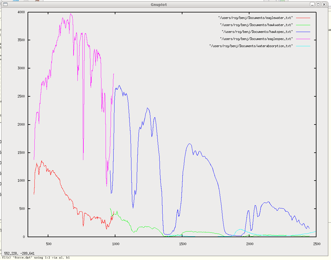
If you plot Eagle and Hawk processed output on the same graph (see attachment) there's about a 30nm overlap for the spectral range, and the instruments don't seem to agree in this overlap. Even if the instruments don't give the same magnitude, the absorption features shown should align (and they don't). This suggests that the spectral calibration of one or both instruments may be out by up to 100nm, which appears to be the displacement needed to make the two graphs align. |
|||
