Opened 19 years ago
Last modified 19 years ago
#2 closed support
Support: 15/May/2007, Rachel Gaulton, GB06/05 — at Version 4
| Reported by: | mggr | Owned by: | mggr |
|---|---|---|---|
| Priority: | alpha 4 high | Milestone: | |
| Component: | Support | Keywords: | |
| Cc: | sbg | Other processors: |
Description (last modified by mggr)
Two issues:
- Amer checking on LIDAR.
- Use of bsq with azgcorr
- mggr suspects perhaps the missing scans are throwing off the navigation?
Rachel's initial contact email:
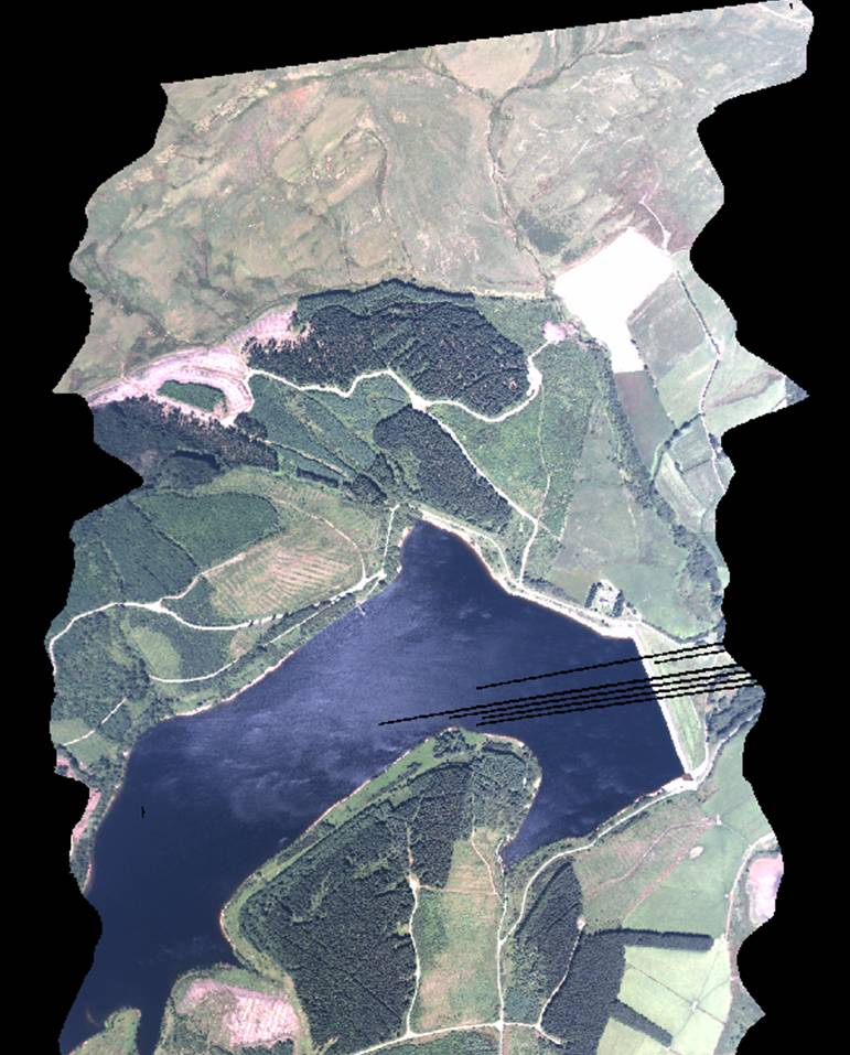
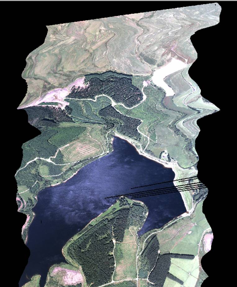
I am trying to process ATM and CASI data flown last summer over my two
sites in Wales (GB06/05, PI - Tim Malthus). Unfortunately we are
having a few problems with AZGCORR and I wanted to check whether you
had encountered them before and had any idea what might be wrong (or
who else might have).

As we are carrying out atmospheric correction before geometrically
correcting the swaths in AZGCORR, so we are using the resulting .bsq
image in conjunction with the original .hdf (and a DTM) as inputs to
AZGCORR, as recommended in the user guide. With the CASI data and most
of the ATM swaths this appears to work ok (at least as far as can be
determined by visual inspection of the results), however with certain
swaths the geometric correction is not successful. These seem to be
swaths with considerable numbers of missing pixels / scan lines.  When
the raw .hdf data is geometrically corrected directly, the problems do
not appear and AZGCORR  works correctly (attached jpeg1), but when the
image is first converted to .bsq and atmospherically corrected the
image seems to be corrected up until the point of the missing scan
lines, but after that appears to be just 'stretched' to fit the
correct outline (jpeg2). The same problem is also being encountered by
John Dowens in correcting strips from GB06/07.

Do you have any ideas what may be causing this problem? Any
suggestions very much appreciated.  I was also wondering if you know
when I might be likely to receive the remaining LIDAR data from this
acquisition (I have the lidar from my Glasfynydd site but not from
Clocaenog)?


Change History (6)
Changed 19 years ago by mggr
comment:1 Changed 19 years ago by mggr
Steve replied and asked for additional info while we're trying to reproduce. Rachel replied back with:
> Many thanks for your response and help. Command string is
> below as requested. The DTM used is attached in case this is
> of use. The file a195041b_atm.bsq is the output of
> atmospheric correction in the ATCOR program which is
> formatted as a .bsq with an ENVI header. Bit big to email but
> can find a way to get it to you if necessary.
Command line she used:
~s0455027/loyal_scratch/image_preprocessing/azgcorr/azgcorr.4613 \
  -1 ~s0455027/loyal_scratch/image_preprocessing/a195041b.hdf \
  -3 ~s0455027/loyal_scratch/image_preprocessing/azgcorr/atm/a195043a_atm_gcor.hdf \
  -p 1.5 1.5 -B 3802 12 0 1.0 0.0 0.0 \
  -Bs ~s0455027/loyal_scratch/image_preprocessing/ATCOR/atm/a195041b_atm.bsq \
  -mUKNG -an -hn -in \
  -eh ~s0455027/loyal_scratch/image_preprocessing/azgcorr/glasfyn_dtm.asc \
  -v
DEM stored at ~arsf/arsf_data/2006/dems/glasfyn_dtm.asc
comment:2 Changed 19 years ago by mggr
Her contact details:
<Details removed>
comment:3 Changed 19 years ago by mggr
Implication of her DEM is that the site is Glasfynydd, or 195A.
Processing data to catch up with her.. Project is stored at ~arsf/arsf_data/2006/195A_GB06_05
comment:4 Changed 19 years ago by mggr
- Description modified (diff)
- Owner set to mggr
- Status changed from new to assigned
Note: See
TracTickets for help on using
tickets.
jpeg1 from Rachel's initial email