Opened 18 years ago
Closed 17 years ago
#71 closed support (worksforme)
Support: 22/Oct/2007, Elena Prado, WM2006-04
| Reported by: | mggr | Owned by: | benj |
|---|---|---|---|
| Priority: | immediate | Milestone: | |
| Component: | Support | Keywords: | |
| Cc: | Other processors: |
Description (last modified by benj)
Dear Ivana,

My name is Elena Prado and I am a user to azgcorr. I have some questions for you,

I try to geocorrect CASI images to achieve L3 product. The images were
acquired over Guadalajara (Spain).

Datum transformation

I am using azgcorr with the option of 7 parameters for datum transformation;
the parameters are specially adapted to the flight zone. But when I check the
results, the images have an offsets in coordinates (offset in Xutm = 104
offset in Yutm = 132).

I know that the images are synchronized with the navigation data because the
effects of the aircraft movement have been removed correctly.

The offset in Xutm fit with the difference between WGS84 and European Datum
1950 so I am not sure that the azcorr makes the transformation.

I send you the azgcorr command line:

> azgcorr  -p 3.5 3.5 –bl 45 15 5 -1 –d7 0 131.032 100.251 163.354 -1.2438 -0.0195 -1.1436 -9.39 –mUTM -3 –eh /MDT25_IGN_GUADA_ED50_3m_he.txt –es NO –ua 0 0 -0.465 –ut -59.995 -1 /c154011b.hdf -3 /c154013_ed50.hdf

-p 3.5 3.5 : pixel size 3.5 meters
-bl 45 15 5 -1 CASI bands to georeference 45/15/05
–d7 0 131.032 100.251 163.354 -1.2438 -0.0195 -1.1436 -9.39: seven parameters for datum transformation
-mUTM -3 : UTM projection zone 30. (central meridian longitude -3)
-eh : DEM file in UTM H30 ED50 and ellipsoidal height
-es NO : no geoid undulation
-ua 0 0 0.465 : offset in heading to apply the meridian convergence
-ut -59.995: offset  to correct the synchronization between image and navigation data

Can you help me with the Datum transformation?

ENVI header

I use the azexhdf to get a Envi header.

> azexhdf –h /c154013_ed50.hdf –Be /c154013_ed50.bil

I get a BIL format image with this command line and in other
folder (I don’t know why azexhdf doesn’t write in the same folder)
get another file P9.hdr with the Envi header. But the map info in
the header is not correct. The datum of the L3 image doesn’t appear
in the header file and the coordinate of the header is the SW image
corner coordinate instead of NW image coordinate that ENVI needs.

Map info = {UTM, 1, 1, 562233.00, 4518052.00, 3.50, 3.50, 30, North}

Do you know how I can solve this?

Image line start – line end

I detect that the data have a des-synchronization between the image
and navigation data, this time offset is 59 seconds more or less
This time is equivalent to 909 lines from the first line in the image
L1b. I think that with this scan timing offset (-ut -59.995) the
synchronization is ok, so I don’t know how use the information about
the scan line (start / end) number information.

Can I do without these??

Data extracted from c154011b.hdf
MIsscan: 248
MIsescan: 6009
NVscnum 248 -> 6009
CAsscan: 248
CAescan: 6010
COsscan: 248
COescan: 4205
COscans: 3958

Thanks you very much,

Elena Prado Ortega
<Contact details removed, see internal contact details page>
MailScanner has detected a possible fraud attempt from "correo.uah.es" claiming to be http://www.geogra.uah.es/teledeteccion-ambiental
___________________________________________________________________ Este mensaje se dirige exclusivamente a su destinatario y puede contener información privilegiada o CONFIDENCIAL. Si vd. no es la persona a quien se dirige este mensaje, queda notificado de que la utilización, divulgación y/o copia sin autorización está prohibida en virtud de la legislación vigente. Si ha recibido este mensaje por error, le rogamos que nos lo comunique inmediatamente por esta misma vía y proceda a su destrucción. This message is intended exclusively for its addressee and may contain information that is CONFIDENTIAL and protected by professional privilege. If you are not the intended recipient you are hereby notified that any dissemination, copy or disclosure of this communication is strictly prohibited by law. If this message has been received in error, please immediately notify us via e-mail and delete it.
Attachments (2)
Change History (11)
comment:1 Changed 18 years ago by mggr
- Status changed from new to assigned
comment:2 Changed 18 years ago by mggr
She also included an azgcorr -v output on request:
pci1@dhaula:~> azgcorr -p 3.5 3.5 -bl 45 15 5 -1 -d7 0 131.032 100.251 163.354 -1.2438 -0.0195 -1.1436 -9.39 -mUTM -3 -eh /samba/makalu_img1/NERC/auxdata/MDT_carto/MDT25_IGN_GUADA_ED50_3m_he_P02_CASI.txt -es NO -ua 0 0 -0.465 -ut -59.994 -1 /samba/makalu_img1/NERC/CASI_060603/L1b/P01CD/c154011b.hdf -3 /samba/makalu_img1/NERC/CASI_060603/L3/P01AZ/c154013_ed50.hdf -v


-----------------------------------------------------------------------
azgcorr  -- ver: 4.7.9-lin Apr  9 2007   (C) Azimuth Systems UK 1996, 2007

data recorded in year: 2006  date: 03/06/2006
CCD type [1]: CASI scanner details and data

HDF level 1 input file: /samba/makalu_img1/NERC/CASI_060603/L1b/P01CD/c154011b.hdf
CCD CApsfov table from hdf file with: 512 entries

Processing Enhanced Spectral data

CCD init opt: 8 pix: 511 bands: 48 fpix: 511
CASI mode: EN-Spectral looks: 511 spacing: 0 centre: 256

Scanner: CASI image (CAimage) pixels: 511 lines: 5762 bands: 48
  config: VEG
  view angles port: -26.2217 star: 26.7592

Navigation...
  navigation spheroid: INTERN  map projection spheroid: INTERN
  datum shift type: DUTCH  map projection: UTM

  site lat/lng start: 40.9744662 -2.2453060  end: 40.8107747 -2.2469343
       grid    start: 563498.6   4536275.8   end: 563517.9   4518102.9
  flight line grid azimuth: 179.9   direction to: South
  nav  index values from:     0  to:  3957
  scan index values from:   908  to:  4865
  navigation attitude items...
     Pitch  use status: file value unchanged
     Roll  use status: file value unchanged
     Heading  use status: file value unchanged

Pixel spacing stats... along line...
   centre     min: 4.31 max: 4.85 ave: 4.59
   port       min: 0.19 max: 22.91 ave: 7.79
   starboard  min: 0.52 max: 27.88 ave: 7.99
   across line centre (pix 255): 4.01

Site details...
  input lines to be processed: 3958
  corrected image pixels : 848  lines: 5246
  limits from scans x: 562130.3 565092.2  y: 4517921.9 4536275.8
  pixel/line limits x: 562128.0 565092.5  y: 4517919.0 4536276.5

HDF data items to level 3 output file: /samba/makalu_img1/NERC/CASI_060603/L3/P01AZ/c154013_ed50.hdf

Correction init  interpolation: BiCub  pixel size X: 3.50 Y: 3.50
DEM file: /samba/makalu_img1/NERC/auxdata/MDT_carto/MDT25_IGN_GUADA_ED50_3m_he_P02_CASI.txt
    limits SW: 561987.5 4520567.0  NE: 567034.5 4540212.5
    order (1): N-S cols: 1443 rows: 5614 grid inc: 3.5
** info: one or more grid limits are NOT multiples of the grid increment

DEM source: User flatfile
   name  : /samba/makalu_img1/NERC/auxdata/MDT_carto/MDT
   limits  x:   562068 to  565152  y:  4517860 to 4536332
   (image) x:   562128 to  565092  y:  4517919 to 4536276
   cols: 882  rows: 5279  xinc: 3.5  yinc: 3.5
   height range  from: 994.0  to: 1374.0
   NO geoid-spheroid correction applied

HDF image access...

read hdf  bands: 48 pixels: 511 lines: 5762
  Image input HDF file: /samba/makalu_img1/NERC/CASI_060603/L1b/P01CD/c154011b.hdf
  input  level1 image: CAimage   bands: 48 pix: 511 lines: 5762
  HDF output file: /samba/makalu_img1/NERC/CASI_060603/L3/P01AZ/c154013_ed50.hdf
  output level3 image: CAimage   bands: 3 pix: 848 lines: 5246
Correcting bands:   45 15 5
Correction rate: 126  input lines per second

Processing Scene Recovery Channel (SRC)


Scanner: CASI image (CAsrc) pixels: 512 lines: 5762 bands: 1
  config: VEG
  view angles port: -26.3117 star: 26.7592

Navigation...
  navigation spheroid: INTERN  map projection spheroid: INTERN
  datum shift type: DUTCH  map projection: UTM

  site lat/lng start: 40.9744662 -2.2453060  end: 40.8107747 -2.2469343
       grid    start: 563498.6   4536275.8   end: 563517.9   4518102.9
  flight line grid azimuth: 179.9   direction to: South
  nav  index values from:     0  to:  3957
  scan index values from:   908  to:  4865
  navigation attitude items...
     Pitch  use status: file value unchanged
     Roll  use status: file value unchanged
     Heading  use status: file value unchanged

Pixel spacing stats... along line...
   centre     min: 4.31 max: 4.85 ave: 4.59
   port       min: 0.19 max: 22.94 ave: 7.80
   starboard  min: 0.52 max: 27.88 ave: 7.99
   across line centre (pix 256): 4.01

Site details...
  input lines to be processed: 3958
  corrected image pixels : 849  lines: 5246
  limits from scans x: 562125.7 565092.2  y: 4517921.7 4536275.8
  pixel/line limits x: 562124.5 565092.5  y: 4517919.0 4536276.5

updating hdf

HDF updated data items to level 3 output file: /samba/makalu_img1/NERC/CASI_060603/L3/P01AZ/c154013_ed50.hdf

Correction init  interpolation: BiCub  pixel size X: 3.50 Y: 3.50
DEM file: /samba/makalu_img1/NERC/auxdata/MDT_carto/MDT25_IGN_GUADA_ED50_3m_he_P02_CASI.txt
    limits SW: 561987.5 4520567.0  NE: 567034.5 4540212.5
    order (1): N-S cols: 1443 rows: 5614 grid inc: 3.5
** info: one or more grid limits are NOT multiples of the grid increment

DEM source: User flatfile
   name  : /samba/makalu_img1/NERC/auxdata/MDT_carto/MDT
   limits  x:   562068 to  565152  y:  4517860 to 4536332
   (image) x:   562124 to  565092  y:  4517919 to 4536276
   cols: 882  rows: 5279  xinc: 3.5  yinc: 3.5
   height range  from: 994.0  to: 1374.0
   NO geoid-spheroid correction applied

HDF image access...

read hdf  bands: 1 pixels: 512 lines: 5762
  Image input HDF file: /samba/makalu_img1/NERC/CASI_060603/L1b/P01CD/c154011b.hdf
  input  level1 image: CAsrc   bands: 1 pix: 512 lines: 5762
  HDF output file: /samba/makalu_img1/NERC/CASI_060603/L3/P01AZ/c154013_ed50.hdf
  output level3 image: CAsrc   bands: 1 pix: 849 lines: 5246
Correcting band:   1
Correction rate: 125  input lines per second

updating hdf

End of azgcorr run - files complete
Note she has azgcorr.479. I've linked her to the newest (.484) which has some datum handling updates.
Changed 18 years ago by mggr
comment:3 Changed 18 years ago by mggr
Hi Mike,

I downloaded the azgcorr.4.8.4 from the FTP site and I ran it with the same options and –v :)

The images have been corrected of the aptitude angles but these images have offsets in coordinates (Xutm offset ≈ 30 m; Yutm offset ≈ 95 m) so I think that the problem is the datum transformation, but this is the first time that I use the azgcorr (I use the PARGE software usual) so I don’t know if I am doing wrong another thing.

I attach the report of azgcorr.4.8.4 and a quicklook of the result, one subset of the first geocoded flight line with a vector layer.

Best regards,

Elena.

___________________________________________________________________ Este mensaje se dirige exclusivamente a su destinatario y puede contener información privilegiada o CONFIDENCIAL. Si vd. no es la persona a quien se dirige este mensaje, queda notificado de que la utilización, divulgación y/o copia sin autorización está prohibida en virtud de la legislación vigente. Si ha recibido este mensaje por error, le rogamos que nos lo comunique inmediatamente por esta misma vía y proceda a su destrucción. This message is intended exclusively for its addressee and may contain information that is CONFIDENTIAL and protected by professional privilege. If you are not the intended recipient you are hereby notified that any dissemination, copy or disclosure of this communication is strictly prohibited by law. If this message has been received in error, please immediately notify us via e-mail and delete it. ___________________________________________________________________


pci1@dhaula:~> azgcorr -p 3.5 3.5 -bl 45 15 5 -1 -d7 0 131.032 100.251 163.354 -1.2438 -0.0195 -1.1436 -9.39 -mUTM -3 -eh /samba/makalu_img1/NERC/auxdata/MDT_carto/MDT25_IGN_GUADA_ED50_3m_he_P02_CASI.txt -es NO -ua 0 0 -0.465 -ut -59.994 -1 /samba/makalu_img1/NERC/CASI_060603/L1b/P01CD/c154011b.hdf -3 /samba/makalu_img1/NERC/CASI_060603/L3/P01AZ/c154013_ed50.hdf -v

-----------------------------------------------------------------------
azgcorr  -- ver: 4.8.4-lin Aug 13 2007   (C) Azimuth Systems UK 1996, 2007

data recorded in year: 2006  date: 03/06/2006
CCD type [1]: CASI scanner details and data

HDF level 1 input file: /samba/makalu_img1/NERC/CASI_060603/L1b/P01CD/c154011b.hdf
CCD CApsfov table from hdf file with: 512 entries

Processing Enhanced Spectral data

CCD init opt: 8 pix: 511 bands: 48 fpix: 511
CASI mode: EN-Spectral looks: 511 spacing: 0 centre: 256

Scanner: CASI image (CAimage) pixels: 511 lines: 5762 bands: 48
  config: VEG
  view angles port: -26.2217 star: 26.7592

Navigation...

Projection and datum shift details initialised....
Spheroid name: INTERN
  semi-major: 6378388.00000  semi-minor: 6356911.94613  e^2: 0.006722670 1/f: 297.000000000
Projection name: UTM
  origin  lat: 0.0000  long (central meridian) : -3.0000
  grid coords at origin  easting: 500000.00  northing: 0.00
  scale factor: 0.99960000  hemisphere: north
Datum shift name: SING
  old spheroid name: INTERN
  semi-major: 6378388.00000  semi-minor: 6356911.94613  e^2: 0.006722670 1/f: 297.000000000
  dx: 131.0320 dy: 100.2510 dz: 163.3540 metres  sc: -9.390000  ppm
  rx: -1.2438 ry: -0.0195 rz: -1.1436 secs

  site lat/lng start: 40.9744662 -2.2453060  end: 40.8107747 -2.2469343
       grid    start: 563601.7   4536319.0   end: 563620.9   4518146.7
  flight line grid azimuth: 179.9   direction to: South
  nav  index values from:     0  to:  3957
  scan index values from:   908  to:  4865
  navigation attitude items...
     Pitch  use status: file value unchanged
     Roll  use status: file value unchanged
     Heading  use status: file value unchanged

Pixel spacing stats... along line...
   centre     min: 4.31 max: 4.85 ave: 4.59
   port       min: 0.22 max: 24.43 ave: 8.12
   starboard  min: 0.28 max: 29.73 ave: 8.34
   across line centre (pix 255): 4.29

Site details...
  input lines to be processed: 3958
  corrected image pixels : 905  lines: 5250
  limits from scans x: 562140.9 565300.5  y: 4517953.1 4536319.0
  pixel/line limits x: 562138.5 565302.5  y: 4517950.5 4536322.0

HDF data items to level 3 output file: /samba/makalu_img1/NERC/CASI_060603/L3/P01AZ/c154013_ed50.hdf

Correction init  interpolation: BiCub  pixel size X: 3.50 Y: 3.50
DEM file: /samba/makalu_img1/NERC/auxdata/MDT_carto/MDT25_IGN_GUADA_ED50_3m_he_P02_CASI.txt
    limits SW: 561987.5 4520567.0  NE: 567034.5 4540212.5
    order (1): N-S cols: 1443 rows: 5614 grid inc: 3.5
** info: one or more grid limits are NOT multiples of the grid increment

DEM source: User flatfile
   name  : /samba/makalu_img1/NERC/auxdata/MDT_carto/MDT
   limits  x:   562079 to  565362  y:  4517898 to 4536382
   (image) x:   562138 to  565302  y:  4517950 to 4536322
   cols: 939  rows: 5282  xinc: 3.5  yinc: 3.5
   height range  from: 994.0  to: 1374.0
   NO geoid-spheroid correction applied

HDF image access...

read hdf  bands: 48 pixels: 511 lines: 5762
  Image input HDF file: /samba/makalu_img1/NERC/CASI_060603/L1b/P01CD/c154011b.hdf
  input  level1 image: CAimage   bands: 48 pix: 511 lines: 5762
  HDF output file: /samba/makalu_img1/NERC/CASI_060603/L3/P01AZ/c154013_ed50.hdf
  output level3 image: CAimage   bands: 3 pix: 905 lines: 5250
Correcting bands:   45 15 5
Correction rate: 107  input lines per second

Processing Scene Recovery Channel (SRC)


Scanner: CASI image (CAsrc) pixels: 512 lines: 5762 bands: 1
  config: VEG
  view angles port: -26.3117 star: 26.7592

Navigation...

Projection and datum shift details initialised....
Spheroid name: INTERN
  semi-major: 6378388.00000  semi-minor: 6356911.94613  e^2: 0.006722670 1/f: 297.000000000
Projection name: UTM
  origin  lat: 0.0000  long (central meridian) : -3.0000
  grid coords at origin  easting: 500000.00  northing: 0.00
  scale factor: 0.99960000  hemisphere: north
Datum shift name: SING
  old spheroid name: INTERN
  semi-major: 6378388.00000  semi-minor: 6356911.94613  e^2: 0.006722670 1/f: 297.000000000
  dx: 131.0320 dy: 100.2510 dz: 163.3540 metres  sc: -9.390000  ppm
  rx: -1.2438 ry: -0.0195 rz: -1.1436 secs

  site lat/lng start: 40.9744662 -2.2453060  end: 40.8107747 -2.2469343
       grid    start: 563601.7   4536319.0   end: 563620.9   4518146.7
  flight line grid azimuth: 179.9   direction to: South
  nav  index values from:     0  to:  3957
  scan index values from:   908  to:  4865
  navigation attitude items...
     Pitch  use status: file value unchanged
     Roll  use status: file value unchanged
     Heading  use status: file value unchanged

Pixel spacing stats... along line...
   centre     min: 4.31 max: 4.85 ave: 4.59
   port       min: 0.22 max: 24.47 ave: 8.13
   starboard  min: 0.28 max: 29.73 ave: 8.34
   across line centre (pix 256): 4.29

Site details...
  input lines to be processed: 3958
  corrected image pixels : 906  lines: 5250
  limits from scans x: 562136.0 565300.5  y: 4517952.8 4536319.0
  pixel/line limits x: 562135.0 565302.5  y: 4517950.5 4536322.0

updating hdf

HDF updated data items to level 3 output file: /samba/makalu_img1/NERC/CASI_060603/L3/P01AZ/c154013_ed50.hdf

Correction init  interpolation: BiCub  pixel size X: 3.50 Y: 3.50
DEM file: /samba/makalu_img1/NERC/auxdata/MDT_carto/MDT25_IGN_GUADA_ED50_3m_he_P02_CASI.txt
    limits SW: 561987.5 4520567.0  NE: 567034.5 4540212.5
    order (1): N-S cols: 1443 rows: 5614 grid inc: 3.5
** info: one or more grid limits are NOT multiples of the grid increment

DEM source: User flatfile
   name  : /samba/makalu_img1/NERC/auxdata/MDT_carto/MDT
   limits  x:   562079 to  565362  y:  4517898 to 4536382
   (image) x:   562135 to  565302  y:  4517950 to 4536322
   cols: 939  rows: 5282  xinc: 3.5  yinc: 3.5
   height range  from: 994.0  to: 1374.0
   NO geoid-spheroid correction applied

HDF image access...

read hdf  bands: 1 pixels: 512 lines: 5762
  Image input HDF file: /samba/makalu_img1/NERC/CASI_060603/L1b/P01CD/c154011b.hdf
  input  level1 image: CAsrc   bands: 1 pix: 512 lines: 5762
  HDF output file: /samba/makalu_img1/NERC/CASI_060603/L3/P01AZ/c154013_ed50.hdf
  output level3 image: CAsrc   bands: 1 pix: 906 lines: 5250
Correcting band:   1
Correction rate: 106  input lines per second

updating hdf

End of azgcorr run - files complete

comment:4 Changed 18 years ago by mggr
Sounds like .484 helped a little but didn't fix things. I've suggested she tries correcting the pitch and roll too (looks like she's done the yaw), which should give her a workaround. It may be that's all that's required.. on the other hand, it'd be nice to follow this up a bit and see if the datum transformation is indeed being applied correctly (which would involve getting Bill this data so he can check). I've asked her if she'd be ok with giving us a copy of the DEM and asked her to md5sum her .hdf to make sure we have the correct one here..
The other thing is that she seems to be using an HDF (or BIL) in ENVI (since it appears to be the other way up to what I see in a TIF), so I suggested she try a GeoTIFF too - this may have the correct header information in it if we're lucky, though I'm not holding out great hopes..
comment:5 Changed 18 years ago by mggr
Fresh contact (no responses previously):
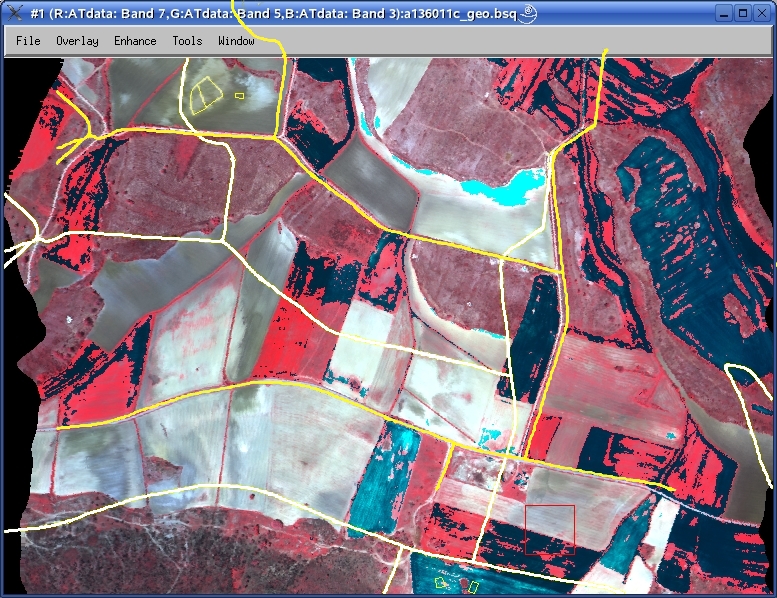
I keep working in the NERC images (ATM, CASI, Eagle and Hawk)
over Guadalajara. I have started to get results but I have
still some problems with the data.

I am working with PARGE and not with AZGCORR, so I extract the
data from the HDF files with AZEXHDF and then I use these
extracted data (image + Exterior Orientation Parameters) and
DEM to georeference the L1b images. Then I check the results
with vectors.

In the process, I assume that the coordinates in HDF, COlat,
COlng and COhgt, are in WGS84 system and ellipsoidal height
(over WGS84 ellipsoid) so I transform in MATLAB these coordinates
to UTM European 1950 system and orthometric height (over geoid).

The results for the images of the second flight day (day 154) are
ok, although the CASI images are desynchronized with the EO
Parameters (this is another subject). But the same datum
transformation doesn't work with the ATM images acquired in the
first flight day (day 136). I know that there isn't a synchronized
problem because the effects of the platform movements are removed
(see the attached image) and the image only have a displacements
(X: 100 m aprox. Y: 200 m aprox.).

Can you confirm that the datum of the ATM-HDF coordinates of the
136 day is WGS84?? Is possible that the data are in another
reference system??
Her picture with positions of her vectors in white, my moved version of them in yellow (demonstrating it's more than just a simple offset).

Confirmed the nav is in WGS-84, mentioned boresight (gave params). Pretty hard to tell where the errors are, so I asked her if we could have a copy of the DEM and vectors for internal testing.
Said we'd have a go at processing the Applanix again to see what the quality was like - Ivana did this previously and just gave us the sbet, so we have no idea of the original quality.
Also suggested using GCPs as a last resort.
comment:6 Changed 18 years ago by mggr
Re-ran the applanix with the saved settings - quality over the site was green/1/fixed, so it shouldn't have caused any problems.
comment:7 Changed 18 years ago by mggr
- Owner changed from mggr to benj
- Status changed from assigned to new
Elena has uploaded DEMs and vectors to us - see ~arsf/support/20071022-WM2006_05-ElenaPrado/upload
-------------------------------------------------------------------------------------------------------------
L1b image - at sensor radiance - original HDF and extracted BSQ (ENVI format)

L1c image - at sensor radiance geocoded image - with PARGE and with displacements :-/ (ENVI format)

auxdata - DEM_carto -
                                DEM - MDT_UAH_2m_ele -> Digital Elevation Model - UTM H30 European 1950 Orthometric Height (ENVI format)
auxdata - DEM_carto -
                                vectors - cartography of the test zone - UTM H30 European 1950 (shp and evf format)
-------------------------------------------------------------------------------------------------------------
comment:8 Changed 18 years ago by benj
- Description modified (diff)
comment:9 Changed 17 years ago by mggr
- Resolution set to worksforme
- Status changed from new to closed
No further contact for a long time.. closing.
Replied saying we were looking at the problem (confirmed project code).
We need to check for and confirm: